Monday, May 24, 2010

Is SVG ready for comeback?

Support for Scalable Vector Graphics (SVG) standard is quietly sneaking into more and more applications and is included in more and more technology platforms. Til recently the whole concept of SVG seemed like a lost cause. However, the support for SVG in web browsers is now quite widespread and even Internet Explorer will now support it natively in the upcoming version 9. And, unlike Flash, SVG works fine on iPhone and iPad devices.

There was a time of high expectations for SVG (about 6-7 years ago) where it has been hailed as an open source replacement for Flash. But then lack of support in major browsers derailed the whole initiative. The usual suspect, Microsoft, opted to promote its own version of vector graphics standard instead. Plug-in for Internet Explorer developed by Adobe was the only lifeline but support seems to be withdrawn for it some time ago. I don’t know if use of vector graphics in Google Map was a turning point but it definitely helped to bring some attention back to SVG.

When I first came across SVG I got very enthusiastic about the whole idea. The ability to include just a few lines of code in html page, as an ordinary XML text, and create stunning animations and visual effects was such an attractive proposition. It was a breeze in comparison with convoluted JavaScript hacks to enable some web page interactivity before Web 2.0 era truly emerged. But then the reality hit hard. The only way to view those graphics was in IE browser with a plug-in from Adobe. So SVG never caught up with the popularity of Flash.

I actually started playing with SVG even before I created my first map (which led me to my adventure with aus-emaps.com and this blog). I dusted off some old code to highlight the stunning capabilities of SVG. Here is a text rendering example that you can only dream to be able to do with CSS (note shadow and emboss effects!):

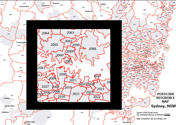
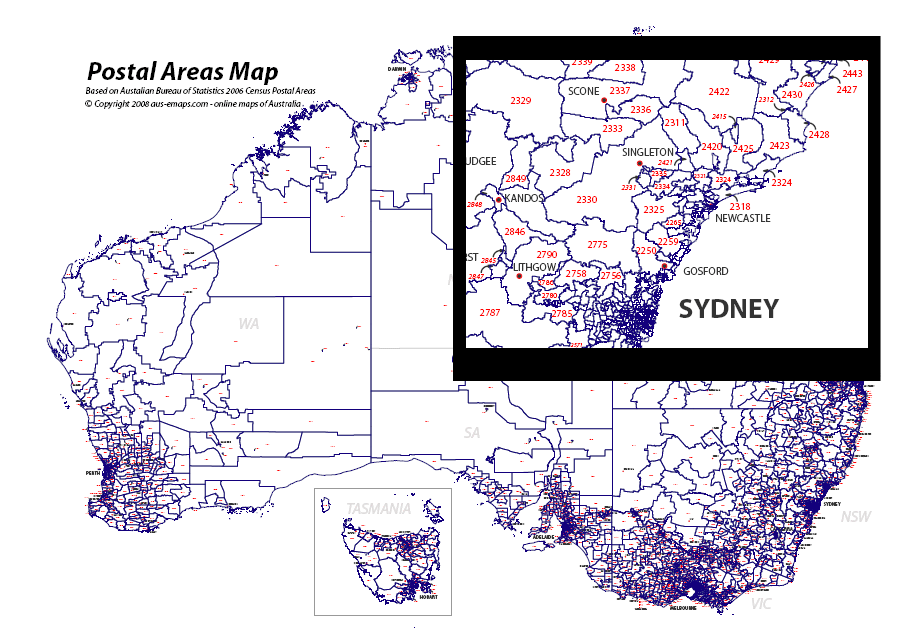
And to finish off, one more example of use of SVG as a mapping application, form Germany:


I believe it’s time to revisit SVG capabilities in the context of the latest developments. Support is not yet uniform across all the browsers, for example some filter effects are not supported in Opera, but SVG deserves a second chance!

Friday, May 21, 2010

Google enables map customisation

Google is making lots of new exciting announcements this week using its I/O conference as the main venue to demonstrate the latest product updates as well as new products and services. The one that caught my specific attention is a functionality upgrade to Google Map v3 which allows developers to customise map appearance. You are no longer limited to standard “look and feel” of Google Maps that many are now so accustomed to. By making simple adjustments to the code Google will now serve maps that are altered to specific developer requirements - in terms of visual appearance of the map and its content. Some examples can be found on Google site. Google also provided a wizard application to help in defining map parameters.

I am excited about this new development not because you can now make all sorts of strange looking maps but because Google is only a step away from enabling full customisation of the content of maps that goes beyond just a few markers, lines or polygons! Another point in case that Google Map is fast becoming a fully featured GIS, but in its own very unique way.


First spotted on Google Maps Mania

Related posts:
Free GIS Tools – Google Map
Ingenuity of Google Map architecture also its main limitation

Thursday, May 13, 2010

Data overload makes SDI obsolete

In 2009 the World created 0.8 Zettabytes of data (that is 800 billion gigabytes!). In 2010 that number will increase to 1.2 Zettabytes. And the volume is growing exponentially from year to year…. If we believe that “80% of data has spatial component” the chances of cataloguing it all and making discoverable in rigid Spatial Data Infrastructure (SDI) type of environments are very slim. So, the only hope we have for making any sense out of this mountain of data is to turn to unstructured search concept rather than meticulous cataloguing, as argued for some time now by Ed Parsons, the Geospatial Technologist of Google.

Australian government is embarking on the new era and opening up its vaults of data to the public but the way this task is executed already attracted some early criticism for not involving State Governments and private industry. Let’s hope this will not turn into yet another failed SDI initiative...

Monday, May 10, 2010

Yell.com adds 3D map view

There is a new 3D map on the market. A popular UK local search and business directory portal Yell.com has just added 3D view option to their online map. It is a totally different approach than Google and Microsoft’s 3D Earth concept or NearMap 4-directional flat view option. Yell.com has opted for a solution that appears to drape multi-directional aerial imagery over 3D point cloud. It offers true 360 degree view of objects on the ground and the map also has a control to adjust the tilt of the camera to the horizon. The level of detail is quite impressive and 3D effect is very realistic when you move around the map.

Yell.com map requires Flash Player and the map is viewable in a standard browser without additional plug-ins. For now Yell.com map covers four cites: London, Manchester, Leeds and Birmingham, but more UK towns will be added soon.

Related posts:

Map of the future
Google introduces Aerial View
3D Earth View added to Google Maps
Google Street View in 3D
Google Flash Map goes 3D

Friday, May 7, 2010

Banks turn to iPhone virtual reality apps

While financial realities are causing havoc on the world’s stock markets, Australian banks have turned to Virtual Reality applications to fight over domestic retail clients. The Commonwealth Bank, Australia’s biggest home lender, has teamed up with rpdata.com and realestate.com.au and released Augmented Reality app for iPhone to, quote, “help Australians make an informed decision when it comes to making their biggest financial commitment”.

CBA media release reads: “The core functionality of the application utilises augmented reality where rich data including past sales history (on more than 95 per cent of properties in Australia), current property listings and recent sales, is mapped on to a real world view through the iPhone’s camera.”

“Users can also switch to a list or bird’s eye view to pull in insights on properties matching their search criteria. Home hunters can then track their ‘dream house’ in their favourites, send to a friend and make informed decisions with access to detailed suburb profiles revealing demographics, median price, property hotspots and capital growth trends.”

Application will be available for free download from iPhone store within a week or so. Android version apparently in the pipeline.

But CBA is not the first to the market. St. George bank released its application, The Housefinder App - developed by Insqribe – a few days earlier. And it is already available for free download from Apple's iTunes or iPhone App store.

"With this new App, you can point the camera on your iPhone at a house or apartment in which you are interested and the screen will display current for sale or rental information, as well as data on what nearby properties have sold for recently."

"The App also lets you search for properties available for sale or rent by suburb, or by your current location, using your iPhone's GPS technology. You can even filter your search based on price range, property type, recent sales information and suburb. All the essential property details are available at your fingertips including the contact details of the real-estate agent."

"In addition to property listing and previous sale information, Housefinder can map St.George Bank branch locations and connect customers to a St.George home lending expert,"

Housefinder's augmented reality function is supported on Apple iPhone 3GS devices. The App uses Google Maps view on earlier versions of the iPhone.


Update: 9/10/2010
ANZ Bank has joined other major banks and released its own property search application for iPhone called ANZ Property Tracker. It is a fully featured app with maps and comprehensive listings provided by Domain and Australian Property Monitors. Key features mentioned by users include: ability to make notes about visited properties, view the last sales price of properties for free, share properties of interest with family and friends via Twitter or Facebook and use a diary function for organising open for inspections and auction dates (times and reminder alerts).

Wednesday, May 5, 2010

Governments intensify free data efforts

iTwire reported earlier this week that Finance Minister Lindsay Tanner and Special Minister of State Joe Ludwig largely accepted 12 of the 13 recommendations of the Government 2.0 Taskforce report. It raises hope that appropriate resources will be found in due course to continue and extend data.australia.gov.au initiative started by the Taskforce. A new blog has been launched to "continue the conversation" with all interested parties. Ideally, there should be a coordinated approach to cataloguing of all free public information in Australia to ensure easy discoverability. For now State and Federal agencies are going alone so access to data is still decentralised. However, it is good to see everyone is moving in the same direction.

UK government launched its data.gov.uk initiative only a few months ago but it appears to be more advanced in the quest to liberate public sector information and data than Australia. What is particularly impressive is that they offer not only data for download but also as web services. In addition, they also catalogue applications developed with government data by individuals and private companies. This is a model worth implementing in Australia.

The Americans have the longest tradition of providing centralised access to free government data and their data collection goes into hundreds of thousands. They continuously improve the functionality of the cataloguing service but it is still quite a challenge to find what you are looking for. Actually, all of the initiatives mentioned above use traditional structured query approach and none of them allow for discovering what data exists for a particular location of interest (ie. spatial search). I guess, the challenge is still too big as it requires adequately structured metadata across all datasets.


End note:

To celebrate the release of Data.gov portal Sunlight Labs is organizing a mashup competition “Apps for America 2” sponsored by Google, O'Reilly Media, and TechWeb. Entries close on August 7th, 2010 and top prize is U$10,000.

Tuesday, May 4, 2010

TomTom launches online maps

Not so long ago I have reported on this blog that Google has committed to extending its dominance to GPS navigation services on mobile phones. Now it looks that the table has turned and TomTom, a major in-car GPS Navigation company, has launched an online mapping application in direct competition with Google.

For now TomTom’s positioning for this application appears to be just route planning however the functionality is very basic: just fixed “From…to” option, without ability to add stopovers or adjusting the route for a mode of transport or other preferences like avoiding tolls or highways. There is an option to specify time of the day so, I presume TomTom has some capability of adjusting results depending on historical traffic conditions but it does not seem to work in Australia. The application apparently takes advantage of TomTom’s core technologies, IQ Routes and Map Share, in planning the best routes but it is hard to see what is so special about these in the online version. Base maps are provided by Telstra’s Whereis.

According to an article in Dynamic Business: “The introduction of the online Route Planner in Australia marks an important step in [TomTom’s] strategy to make award-winning navigation available to all users, regardless of the platform that is used…” If TomTom is serious about this strategy they have to add much more functionality and possibly open the platform to independent developers. Otherwise it just looks like a desperate move by a company that has a lot to loose to Google in mobile GPS navigation market so it tries to gain some ground in the online market to compensate…

Monday, May 3, 2010

Large format PDF Postcode Maps

Last weekend I have quietly launched another postcode related initiative – large format Postcode Maps in PDF format. The first batch includes maps covering Sydney, Melbourne and the ACT as well as postcodes in remote and rural areas and is based on Census 2006 Postal Area boundaries distributed by the Australian Bureau of Statistics. The maps are suitable for printing on local printers (eg as “banner” A4 tiles) as well as on large format commercial plotters.

There are two product lines for now:
I have to mention a caveat that because Capital Cities Maps are generated by print function of a browser they have only standard resolution imagery in the background (at 96 dpi) so, they are not as sharp and crispy-clear as commercially printed street directories (see sample).

These maps are available for download from aus-emaps.com site for a small fee – but be warned, Capital Cites Maps are big - 80 to 260MB, depending on the coverage area. Printing and lamination can be arranged on request. I have made an undertaking that $10 from sale of every map containing OpenStreetMap imagery will be donated to OSM Foundation to support this great initiative.

I started experimenting with large format print from common browsers a while ago but so far I did not find any practical use for it. This is my first attempt to test the process in a production capacity. The process is relatively straightforward and can be used for “rapid creation” of custom maps but, since it involves a friendly graphic designer to generate the final version of the file with all relevant annotations, I am unable to provide those maps for free…

I have selected OpenStreetMap as a background image option since it is free to use under Creative Commons licence and I can charge for the derived product. Although technically it is also possible to produce maps with any Google imagery since they are generated directly from a browser and not through “assembly of individual map tiles”, which is specifically prohibited under the terms of use however, such maps could only be created for personal perusal, as defined by Google.

This is just an experiment to test the market for large format custom PDF maps. If there is any interest in these maps I will follow with the remaining capital cities and maybe some other administrative boundaries as standard options. Your feedback and comments most welcome.


Other related tools

Large format Postcode Maps complement a range of free postcode related tools from aus-emaps.com. These include Postcode Finder web widget for embedding into websites, thematic map with postcode and suburb boundary overlays, more advanced version called Postcode Finder map as well as demographic maps and demographic data tools containing information from 2006 Census of population and housing published by the Australian Bureau of Statistics. There are also free graphic vector files with outlines of Australia and capital cities available for download. More free resources to come!


Related posts:
Free postcode search widget
Post code maps and population statistics